Skip to content
Spatial Dimensions is a UK measured building survey and geospatial company, established in 2012, delivering point cloud surveys nationwide from permanent offices in London, Sevenoaks and Nottingham. Every cloud is captured with our own Leica laser scanners as part of our laser scanning surveys service, and processed in-house by our own technicians — never outsourced.
In short: a point cloud survey from Spatial Dimensions records every visible surface of your building or site as millions of individually measured 3D points on a known coordinate system. You receive it in colour or black and white, in .RCS, .RCP, .E57, .PTS or .PTG format — as files, or hosted on a secure online portal your whole team can open in a browser — ready for dimensional verification, design coordination, CAD drawings or a Revit model. Surveys start at £850.
or call 01732 458799

What is a point cloud?
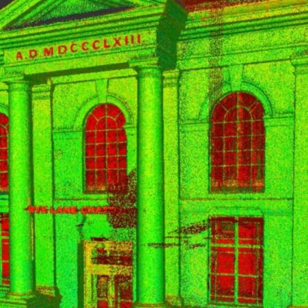
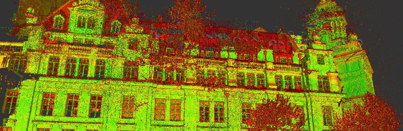
A point cloud is a 3D dataset made up of millions — on large projects, billions — of individually measured points, each with its own position in three dimensions. A laser scanner sweeps the site with laser pulses, and every surface the beam touches becomes a measured point. Spatial Dimensions then registers the scans — aligns them into one continuous dataset on a single known coordinate system.
Because the scanner records everything in its line of sight, the cloud captures all visible detail and the surrounding context of your site, not just the features on a specification list. Detail nobody asked for at the outset can still be measured and drawn up later, without another site visit.
A point cloud is not a 3D model. The cloud is the measured record; a model is built from it. If your team needs modelled walls, doors and structure rather than measured points, see our 3D models page — many clients commission both.
What is a point cloud survey used for?
A point cloud gives you a dimensionally accurate dataset of everything visible on site, which your team can measure from a desk. Clients commission Spatial Dimensions point clouds to:
- Verify dimensions and as-built conditions — check what was actually built against what was designed, without a site visit
- Coordinate the design team — architects, contractors and consultants work from one dataset, shared through secure online portals for RIBA Stage 3 spatial coordination
- Support design, analysis and clash detection — BIM coordinators use the cloud to catch conflicts before they become costly variations
- Produce drawings and models — the cloud is the base data for our measured building surveys, CAD drawings and Revit models
- Navigate the space virtually — walk the building on screen instead of revisiting site
- Keep a timestamped historical record — a dated, measurable archive of the building for restoration and insurance
Where detail sits outside the scanner’s line of sight, such as roofscapes, Spatial Dimensions can supplement the cloud with drone photogrammetry.
What formats does a point cloud come in?
Spatial Dimensions delivers point clouds in the format your software actually reads — tell us what your team uses and we match it.
Swipe the table sideways to see all the columns.
| Choice | Options |
|---|---|
| Format | .RCS and .RCP for Autodesk software; .E57, open and vendor-neutral; .PTS and .PTG; others on request |
| Colour | Black and white, or full colour (RGB) |
| Density | Full density, or decimated to an agreed lighter density |
| Delivery | File transfer, or hosted on a secure online portal and viewed in a browser |
Colour or black and white? A colour cloud carries real-world colour applied from panoramic imagery captured at each scan position, which makes it far easier for non-surveyors to read. The trade-off is more time on site and larger files; black-and-white clouds are quicker to capture, smaller to store, and dimensionally identical. State your preference at quotation stage — it affects price and programme.
How big are point cloud files, and how do you manage that?
Honestly, big — a full-building cloud can run to billions of points, and colour makes it bigger. Spatial Dimensions keeps the data workable in three ways.
- Decimation — thinning the cloud to an agreed, workable density so it runs smoothly on ordinary hardware, while we keep the full-density original in our archive.
- Format choice — supplying the format native to your software rather than leaving you to convert.
- Hosting — we host the cloud on a secure online portal, including publishing to Leica TruView, a web-based collaboration tool where authorised users navigate the point cloud in a browser. No specialist software, no download.
A surveyor-hosted cloud means consultants and contractors check details online instead of returning to site — fewer disruptions for building occupants and a lower carbon footprint, which is why our retrofit guide recommends it.

How accurate is a point cloud?
Spatial Dimensions states accuracy in writing on every quotation, in line with RICS guidance on Measured Surveys of Land, Buildings and Utilities. Point clouds and the models built from them are specified against the RICS accuracy bands.
Swipe the table sideways to see all the columns.
| Scale | RICS band | Plan accuracy (X,Y) | Height, hard detail | Height, soft detail | Minimum detail shown | |
|---|---|---|---|---|---|---|
| LOD 1 | 1:100 | E | ±50 mm | ±10 mm | ±50 mm | N/A |
| LOD 2 | 1:100 | D | ±20 mm | ±10 mm | ±25 mm | 50 mm |
| LOD 3 | 1:50 | D | ±20 mm | ±10 mm | ±25 mm | 20 mm |
| LOD 4 | 1:20 | C | ±10 mm | ±5 mm | ±15 mm | 10 mm |
Accuracy comes from control, not just the scanner. Every Spatial Dimensions survey is built on a closed-loop control network with redundant observations, anchored to Ordnance Survey benchmarks — OSGB36 in plan, Ordnance Datum in height — unless you ask for a local grid, and the registered cloud is verified against that control before delivery. We capture with Leica BLK, RTC360 and P-series scanners, and every deliverable passes the multi-stage checks of our ISO 9001:2015 quality system — the person who processes a job never signs it off.
The full accuracy tables sit in our Guide to Level of Detail (LOD) for 3D Models, free to download from our guides page.
Can you use a point cloud we already have?
Usually, yes — and if you are a past Spatial Dimensions client, you may not need a new scan at all. Every project is securely archived, so you can commission further deliverables from the original dataset — extra drawings, a Revit model, different formats — years later without paying for a rescan, and later site visits integrate with the original data. Scan once, deliver many times.
If your cloud was captured by another company, Spatial Dimensions can model or draw from it provided the coverage and registration are good enough for the level of detail you need. Send it over and we will tell you plainly whether it is usable.
Who commissions point cloud surveys?
Around 40% of our clients are architects and space planners, 30% property consultants, project managers, quantity surveyors and engineers, and 25% main contractors and site teams. Point cloud deliverables appear on published Spatial Dimensions projects including Unity Campus, Guildford Business Park, 77 Farringdon Road, 77 Gracechurch Street, Bridge House, Axis House, Hinchingbrooke Hospital, Southend University Hospital and Kensington Court Gardens.
We keep dedicated resources for architects, consultants and contractors.

How much does a point cloud survey cost?
A point cloud survey from Spatial Dimensions starts at £850. Most point cloud surveys fall between £850 and £5,000, depending on the size of the building or site and the formats you need.
The price of a point cloud survey depends on the size and complexity of the building or site, how much must be captured inside and out, colour versus black and white (colour adds site time), the density and formats you need, and whether you want the cloud hosted. Spatial Dimensions quotes a fixed price against a written specification, and mobilises to site in an average of 5.3 working days from instruction.
For a fixed price, send us the site address, the approximate floor area and what the data is for. We will come back with a written quote within 24 hours. All prices exclude VAT.
or call 01732 458799
Frequently asked questions
Is a point cloud a 3D model?
No. A point cloud is millions of individually measured points — a record of what exists. A 3D model is intelligent geometry (walls, doors, floors) built from those points. Spatial Dimensions delivers both; see our 3D models page.
What software do I need to open a point cloud?
Spatial Dimensions matches the format to your software: .RCS and .RCP for Autodesk packages, .E57 as an open vendor-neutral format most point cloud software reads, and .PTS or .PTG where preferred. No point cloud software at all? Take the hosted option and use a browser.
Can you host the point cloud for us?
Yes. Spatial Dimensions hosts point clouds on a secure online portal, including Leica TruView, so authorised users across your project team can navigate the data in a web browser without downloading huge files or buying software.
Can you reduce the size of a point cloud?
Yes. Decimation thins the cloud to a density your hardware handles, while Spatial Dimensions archives the full-density original so nothing is lost. We can also host the cloud online so you never handle the raw files.
Should I choose a colour or black-and-white point cloud?
Colour if non-surveyors will use the cloud — it is far easier to read. Black and white if you mainly need modelling base data — faster capture, smaller files, equally accurate measurements. Tell us your preference at quotation.
Can you build a Revit model from a point cloud captured by another company?
Yes, provided the cloud has adequate coverage and registration for the level of detail you need. Spatial Dimensions checks the dataset first and tells you honestly whether it is good enough before you spend anything.
Request a point cloud survey quote
Send us the site address, the approximate floor area, what the data is for and which format your software reads; Spatial Dimensions will reply with a written, fixed-price quote within 24 hours.
Phone: 01732 458799
Offices: London · Sevenoaks · Nottingham · working nationwide
Related services
- Laser scanning surveys — the parent service and capture method
- 3D models — Revit models built from the cloud
- Measured building surveys — drawings of an existing building
- CAD drawings — 2D drafting from the cloud
- Drone surveys — roofscapes and areas outside the scanner’s line of sight