 Skip to content
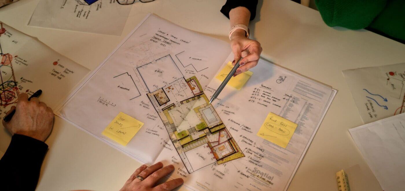
SITE
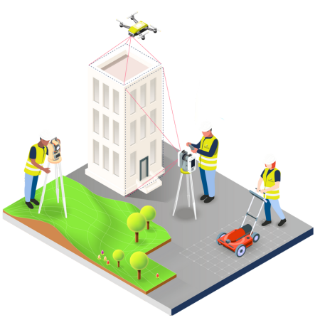
At Spatial Dimensions, we believe that a site visit and surveys are the crucial first step in our process to delivering exceptional results.
Ensuring the highest level of accuracy, we use state-of-the-art technology such as drones and the newest laser scanners. These advanced tools not only enhance the precision of our data but also significantly save time on projects. This enables us to provide our clients with efficient and reliable survey results.
We understand that some projects require the utmost discretion due to their sensitivity. Rest assured that confidentiality is of utmost importance to us. Our team conducts site visits with professionalism, respecting client privacy and project confidentiality at all times.
Ensuring our surveys comply with safety regulations, we follow strict protocols. Our team undergoes necessary safety checks, including Acclaim Health Services (SSIP), DBS, CSCS, and BPSS, ensuring that we maintain the highest standards of safety and security. We take safety on site very seriously. Prior to site visits, briefs are given for travelling to and from site as well as being on site itself. Any specifics required for the job will be covered then to ensure the upmost safety of our employees and clients
As dedicated professionals, we are proud members of the TSA (The Survey Association) and also adhere to the guidelines set by the RICS (Royal Institution of Chartered Surveyors) during surveys. These affiliations therefore demonstrate our commitment to excellence and best practices within the surveying industry.
By starting with a thorough site visit, utilising the latest technology, prioritising discretion, and adhering to safety regulations and industry standards, Spatial Dimensions sets the stage for successful and reliable surveying outcomes. You can trust us to deliver accurate and comprehensive surveys tailored to your unique project requirements.

PROCESSSING
RAW SCANNED DATA
Back in the office, our process begins with gathering the raw scan data from our surveys. Each day, with every laser scanner we use, we capture between 100 and 200 high-resolution scans, which are then copied onto a computer. Typically, a day’s scanning would be around 25-30GB of raw data. Depending on if the scans were colourised (RGB values) would also impact the size of the files. We have invested in super-fast computers to keep the important time minimal. Even with our fast computers, this process can take around 45 minutes to copy to the server, so time to grab and coffee, and catch up on some emails!
Following the data download, our team springs back into action. The scan data is post-processed, eventually forming a dense sea of information called a point cloud. Using Leica’s compatible, user-friendly Cyclone Register 360 software, these points are sorted, linked, and grouped. Think of this as completing a challenging but rewarding 3D jigsaw puzzle!
ACCURACY
But we know speed is just one part of the equation. At Spatial Dimensions, absolute accuracy is always at the heart of our work. That’s where survey control comes into play! With on-site measurements using total stations and GPS (if required), this data ensures the point cloud is precisely positioned and accurate to the required tolerance levels and real-world coordinates.
Our commitment to providing top-notch customer service means we always double-check our processing work. Our technical manager oversees quality assurance, creating a registration report.
After that, we’re left with a brilliantly detailed, comprehensive E57 point cloud, ready to be turned into 2D drawings or 3D models by our CAD team.
Finally, we ensure your data – the ‘gold’ of our operation – is well-guarded. It is stored on our servers and automatically backed up off-site on Microsoft Azure’s secure cloud storage, compliant with ISO27001 (ISO 27001 is a specification for an information security management system). Our backup cloud protects us against hardware failure, ransomware, and human error. If any disaster strikes, it is backed up daily and can be restored with a single click.
DELIVERY
We take pride in our customer-oriented approach, delivering tailored data solutions to meet the specific requirements of our valued clients. As the final step in our comprehensive process, our data delivery services play a crucial role in translating survey measurements into actionable insights and visualisations.
We understand that each project is unique, and our team of experts works closely with our clients to ensure that the delivered data aligns perfectly with their needs and expectations. Whether it’s 2D CAD, 3D Models, Revit, or BIM, we offer a range of data presentation options to cater to diverse project requirements. Our goal is to provide our clients with accurate and detailed data that can be seamlessly integrated into their design and development processes.
Communication is a vital aspect of our approach. Throughout the entire surveying and data delivery process, we maintain close contact with our clients, as a result we actively seeking their input and feedback. This ensures that the end product not only meets their specifications but also exceeds their expectations.
Above all, our commitment to exceptional customer service extends beyond the delivery of data. In addition, we remain readily available to our clients even after the data has been delivered, providing ongoing support and assistance. Whether it’s answering questions, providing further advice, or addressing any concerns, our team is always on hand to help!
Experience the difference with Spatial Dimensions. Contact us today to discuss how our tailored data delivery solutions can empower your project’s success.

WHY CHOOSE SPATIAL DIMENSIONS?
CONSULTATION
We strive to give you the survey data you need as economically as possible. We’ll consult with you on your requirements to make sure we have everything covered and are not collecting information that isn’t needed. Saving you time and money.
CLEAR PROPOSAL
The devil is in the detail as they say. We’ll make sure our proposal to you is clear, concise and details exactly what you are ordering. We’ll aim to get a quote back to you within 48 hours.
PRICE MATCH PROMISE
We want you to get great value for money saving your budget for building amazing spaces that everyone loves. We’re very confident you won’t find a more competitive survey elsewhere for the same quality.
FAST MOBILISATION
Time is money, save some by placing your order online. We’ll quickly arrange access to the site, address any health & safety requirements and get to any location in the UK quickly.
KEEP YOU INFORMED
We’ll update regularly on the progress of the survey Any issues or unforeseen delays will be reported promptly so you can plan your resources to get to work on the deliverables as soon as they are delivered.
QUALITY ASSURED
When you choose Spatial Dimensions you don’t have to worry about quality and accuracy. All surveys are passed through a rigorous QA check to make sure we get it right first time.
Our guarantee to you; if we miss any information that was specified in our proposal, we'll go back and fix it, quickly with no questions asked.