 Skip to content

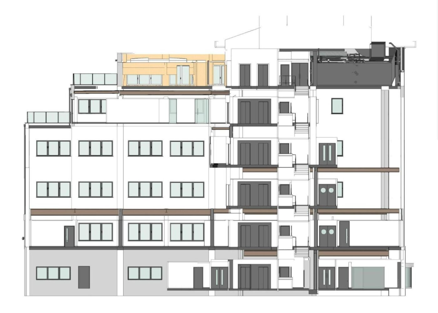
A datum is the fixed starting point that every vertical measurement on a survey is taken from. A level is measured above that datum. A height is measured above something else, such as a floor or the ground, so it goes wrong the moment that thing changes. Spatial Dimensions works to Ordnance Survey grid and datum as standard and gives survey levels, not heights, on its drawings, because a level stays true when a building is stripped out. A datum fixed by satellite positioning is generally acceptable to within about 20 mm, which is why every team on a project should work from the same survey control.
What is the difference between a level, a height and a datum?
A datum is the zero, a level is measured from that zero, and a height is measured from something that isn’t the zero.
- Datum: a fixed point the survey calls zero, or gives a set value. Ideally it sits off site, or somewhere that won’t change. It can be tied to Ordnance Datum Newlyn, the national height datum, or given an arbitrary value.
- Level: how far a point is above the datum. Ground level, floor level, ceiling level and the level of a door head are all measured from the same zero, so you can compare them and subtract one from another.
- Height: how far a point is above something else. You are about 6 ft above the ground: that is a height. A ceiling 2.30 m above the finished floor is a height too.
The catch with a height, as Claire Fenwick puts it, is that someone has to decide what it is measured from. Whatever that is can move.
Prefer to see it? The first episode of our Measured Surveys Explained series, Levels or heights?, shows the difference in a few minutes of animation.
Why do Spatial Dimensions survey drawings show levels, not heights?
Because a height goes out of date as soon as the building changes, and a level doesn’t.
Take a ceiling height of 2.30 m above the finished floor. Lift the carpet and the finished floor drops. The ceiling hasn’t moved, but the 2.30 m on the drawing is now wrong. Strip the building back for a refurbishment and every ceiling height and head height on the drawing is wrong at once, because the floor they were measured from has gone.
A level doesn’t have that problem. The ceiling has its own level above the datum, and so does the floor. Take the carpet up and the floor level changes, but the ceiling level is exactly what it was. As long as the datum point still exists, every level on the drawing still holds, however much changes around it.
That is why Spatial Dimensions gives floors, ceilings and door heads as levels on its measured building surveys. Anyone who needs a height can subtract one level from another. We set a reference level floor by floor, with mezzanines added where they exist, and take slab level from the stair core. In houses and flats, where finishes vary from room to room, we often give an averaged finished floor level and say so.
 READ NEXTLISTED AND HISTORIC BUILDINGS: WHAT TO ASK FOR IN A MEASURED SURVEY
What do AOD and an arbitrary datum mean?

AOD means “above Ordnance Datum”: a level tied to Ordnance Datum Newlyn, the national height datum. An arbitrary datum is a zero the surveyor chooses for one site.
Spatial Dimensions works to Ordnance Survey grid and datum by default. That puts the survey in the right place in the real world: its eastings and northings sit on the national grid, and its levels sit above Ordnance Datum Newlyn. Our explainer, What is Ordnance Datum Newlyn?, covers where that datum comes from. Today surveyors reach it through GNSS (satellite positioning) rather than the old bench mark network.
An arbitrary datum works differently. The surveyor picks a fixed point away from the work, such as a survey peg in the pavement outside a house, and gives it a value. We would usually call it 50 m rather than 0 or 5. A low number risks negative levels as soon as the survey runs down a driveway or into a basement, and minus figures confuse the drawing and whoever reads it.
Some clients and contractors prefer an arbitrary datum and a local grid. National grid coordinates run into the hundreds of thousands, which some design software handles badly, so a local grid keeps the numbers small. On many projects it matters less where the building sits in the world than where it sits against its neighbours. Both approaches work. One is tied to the real world, and the other is convenient for the person using the drawing. What matters is that the drawing says which it is.
Where do datums go wrong on a project?
Most datum problems come from surveys that were never on the same datum, not from bad measuring. These are the ones Claire sees most:
- Several surveys, no datum note. A site has had surveys over the years, and an older one never said which datum it used. Or the surveyor was asked for Ordnance Datum and used their own.
- The control has gone. Survey stations in the ground are often lost when a building is demolished and the site is cleared. A good topographical survey also records hard features that won’t change, such as the corner of a manhole, the corner of a solid wall or a window sill. From four of those, a surveyor can work backwards, find the original position and set out new control.
- Different teams, different control. One firm does the existing survey, another the as-built, a third the engineering setting out, and none of them work from the same control. Everyone assumes every survey agrees to the millimetre. They don’t.
- Two GNSS set-ups, two answers. GNSS is far more accurate than the old bench levels, but a fix within 20 to 30 mm counts as good. Two surveyors who each fix their own datum by GNSS can start 20 mm apart, then carry that difference up every floor of a car park or a large building.
- Levels sprayed on walls. Engineers sometimes mark levels on walls from a different datum to the original survey. Later someone compares the two, and the survey looks wrong when it isn’t.
That last one has a tell. A datum mismatch shows as the same offset everywhere, not as random errors. If every level disagrees by the same amount, check the datum before you doubt the survey.
PLANNING A PROJECT?
Tell us about your site and what you need, and we will come back to you with a quote.
When does the datum matter most?
On every job, but three kinds of work depend on it completely.
- Rights of light. The analysis of sunlight on a building and its neighbours needs everything on one specified datum, agreed from the start.
- Setting out from a planning consent. If the consent fixes a ridge level, say no taller than the house next door, the setting out must use the same datum as the survey behind the consent. On the same datum, the ridge ends up where planning said. On a different one, it can be wrong even when every measurement is right.
- Flood risk. A floor that sits safely above a flood level on one datum can sit below it on another. A datum error can put a building at flood risk when it was never meant to be.
In each case the answer is the same: specify the datum at the start, and make every survey, design and setting-out team use it.
How accurate is a datum?
For a datum fixed by GNSS, Claire’s rule of thumb is that within about 20 mm is acceptable for most work. The right figure depends on how the datum was fixed and what the survey is for.
A good survey never rests on one datum point. Spatial Dimensions sets two or three, so the survey survives if one is destroyed, and averages out the few millimetres between them. Where the purpose is critical, such as a flood risk assessment, the surveyor stays on the point longer, checks the satellites, and repeats the whole observation later in the day. Tying in to the national network of reference stations can tighten a datum to a few millimetres, but it takes time on site.
One caution: the tolerance on a datum is not the tolerance of the survey. How closely the datum is fixed is a separate question from how accurately the survey is measured from it. That depends on the deliverable and the Level of Detail agreed at quotation.
How do you keep every survey on the same datum?
With survey control: a set of fixed, measured points that every survey, design and setting-out team works from. Claire calls it the most important basis of any survey.
On a big site, the owner should hold that control and give it to everyone. Spatial Dimensions has done this work with an NHS hospital trust, where many surveys and datums had built up over the years and the trust invested in a site-wide primary control network. It runs around the whole site and through the middle. Whoever is working, on a building in the middle, a road or the main entrance, has control within reasonable reach. Each team needs at least two control points to fix its position and orientation, and then everyone starts from the same position and the same datum.
Claire’s way of describing it is a jigsaw. The control network is the edge pieces. Once they are down, everyone else’s pieces have to fit inside.
Surveyors build those edge pieces with a traverse: the instrument moves from station to station, sighting back and forward, until the loop closes on where it started. Good practice is well-shaped triangles, as near to equilateral as the site allows, because long, thin triangles are harder to calculate and less accurate. Spacing is a balance. Stations too far apart weaken the measurements, and too many add a small error at each one. A closed loop of four stations should come back within a millimetre or two of its start. A 25-station loop on a big site gets a little more tolerance, but not much.
This matters more now, not less. Laser scanners and handheld scanners produce results that look complete and correct. Without proper control around them, there is no way to prove the scan hasn’t drifted, or that one side hasn’t wandered off in one direction. Control belongs all round the site, not just at one end or along the front.
What does this mean for architects?
The misunderstanding Claire hears most is people saying “level” when they mean “datum”, and the other way round. Three checks before you design from any survey:
- Find the datum note. Is it Ordnance Datum, a client datum or an arbitrary one, and where is the datum point?
- Check each figure is a level, not a height off a floor or ceiling that may change.
- If there is more than one survey, check they share the same control. If every level disagrees by the same amount, it is almost certainly a datum difference.
On a new commission, agree the datum before anyone goes to site, and say so early if the job involves rights of light, a planning ridge level or flood risk.
For anyone starting out in surveying, control and datums are where the discipline of the job shows. A level that is right but on the wrong datum is no more use than a wrong one.
If you’re a surveyor who’d enjoy this kind of work, we’d like to hear from you. We’re always looking for people who take pride in getting the detail right, whether you’re early in your career or bringing years of experience. Take a look at our careers page to see current roles and how to get in touch.
Survey levels FAQs
What is the difference between a level and a height?
A level is measured above a fixed datum, so it stays true when the building changes. A height is measured above something else, such as a floor, and goes wrong if that changes. Spatial Dimensions shows levels on its survey drawings.
What is a datum in surveying?
A datum is the fixed starting point every level on a survey is measured from. It can be tied to Ordnance Datum Newlyn, or set as an arbitrary value on a point that won’t move.
What does AOD mean on a drawing?
AOD means “above Ordnance Datum”: a level measured above Ordnance Datum Newlyn, the national height datum for mainland Great Britain. Spatial Dimensions works to Ordnance Survey grid and datum as standard.
Why would a survey use an arbitrary datum?
It keeps coordinates small for design software, and suits projects where only the position against neighbouring buildings matters. Surveyors give it a high value, such as 50 m, so no level on the drawing goes negative.
How accurate is a survey datum?
For a datum fixed by GNSS, within about 20 mm is generally acceptable. For critical work such as flood risk, longer observations and repeat checks later in the day tighten it.
Why don’t two surveys of the same site line up?
Usually because they sit on different datums or different survey control. If every level is out by the same amount across the site, that points to a datum mismatch, not bad measuring.
Spatial Dimensions has carried out topographical and measured building surveys since 2012, with permanent in-house teams of surveyors, CAD technicians and project managers. Our offices are in Sevenoaks, London and Nottingham. Our Managing Director, Claire Fenwick FCInstCES, is President of the Geospatial Survey Association. Call us on 01732 458799 or get in touch.
Commissioning a survey? Our free guide, Specifying a Topographical Survey, explains survey control, datums and what to ask for.
 DEVELOPER
 CONSULTANT
 ARCHITECT
 ENGINEER
 SURVEYOR
 PLANNER
 CONTRACTOR
 ESTATE AGENT
 LAWYER
 HOMEOWNER