 Skip to content

A listed building survey records a historic building as it actually stands, including its lean, its settlement and its decoration, so the design team and the conservation officer work from the same evidence. Spatial Dimensions surveys listed buildings with non-contact laser scanning, so nothing is fixed to the fabric, and delivers 2D drawings at LOD 4, which is 1:20 at ±5 mm. Measured building surveys start from £850, excluding VAT, and our average time from instruction to site is 5.3 working days.
What makes a listed building survey different?
Three things: the level of detail, the method and the honesty of the drawings. An ordinary measured survey for an office refit can work at LOD 3, which is 1:50. A listed building usually needs LOD 4, because the things that matter to its significance are small: mouldings, masonry joints, spindles and cracks.
The method matters too. On a listed structure, drilling targets into the walls or leaning ladders against the fabric is often not allowed. Spatial Dimensions uses non-contact laser scanning from tripods, and drone photogrammetry for roofs and high elevations that cannot be reached safely from the ground. Nothing is fixed to the building.
Then there is straightness. Historic buildings lean, settle and drift. A survey drawn as if every wall were plumb is easier to design from, but it hides the very thing a conservation officer may want to see. Spatial Dimensions applies perpendicular alignment only where it is workable, and flags any wall that falls outside tolerance because of genuine lean, rather than quietly straightening it.
What level of detail should a heritage survey brief ask for?
Ask for LOD 4 on the parts of the building that carry its significance, and say so element by element. The levels below are the published Spatial Dimensions tolerances for 2D measured building survey drawings:
One caution that saves arguments later. Those figures are for 2D drawings. A 3D model or point cloud at LOD 4 has a different published tolerance: ±10 mm in plan and ±5 mm in height on hard detail. So if a brief asks for “a LOD 4 model to ±5 mm”, it is asking for something the tables don’t say. Name the deliverable and the tolerance together.
If your brief uses the RICS guidance note Measured surveys of land, buildings and utilities (3rd edition), LOD 4 sits in Band C. Band C gives ±5 mm in plan at one standard deviation, ±10 mm at two, and ±5 mm in height on hard detail. Its legacy scale is 1:20, and RICS lists heritage recording among its typical uses.
If Historic England is involved, or the brief is written by a conservation specialist, it may point to Historic England’s Geospatial Survey Specifications for Cultural Heritage. This is the latest revision of its Metric Survey Specifications for Cultural Heritage (the third edition came out in 2015), and it is the specification Historic England uses for its own metric survey framework. Section 5 is a standard specification for measured building survey. It comes with a free project brief template that asks you to settle the points that cause most arguments on heritage jobs:
- the output scale for each drawing
- whether curved walls are drawn straight on or “unwrapped”
- whether overhead detail such as beams and vaulting is shown on plans
- how staircases are annotated and levelled
- which services are drawn
- how window and door opening heights are shown
- whether roofs are drawn with the covering on or off
Filling in that template, or simply answering those questions in your own brief, means every surveyor prices the same scope.
You don’t need LOD 4 everywhere. A plain 1960s rear extension on a listed house can often be drawn at LOD 3, which keeps the cost down without losing anything that matters.
 READ NEXTSURVEYING HOTELS THAT NEVER CLOSE: HOW TO MEASURE AN OCCUPIED HOTEL BEFORE A REFURBISHMENT
What should a listed building survey brief include?
A good brief answers seven questions before the surveyor arrives:
- What is the survey for? Listed building consent, a repair schedule, a conservation management plan or an archive record each need different drawings.
- What is the extent? The building, outbuildings and the curtilage. A topographical survey covers levels, boundaries and landscape within the curtilage.
- What level of detail, and where? LOD 4 on the principal elevations and significant interiors, LOD 3 elsewhere, if that suits the scheme.
- Which drawings? Floor plans, elevations, sections, roof plans and reflected ceiling plans. Say which elevations and which sections.
- Which formats? 2D CAD (.DWG), a Revit model (.RVT, with an IFC copy), a point cloud, or a mix.
- What are the access rules? Opening hours, services, events and any areas where equipment can’t stand.
- What happens when the building isn’t square? Ask for deviations to be shown and flagged, not straightened out.
Spatial Dimensions provides measured surveys on Ordnance Survey grid and datum as standard, so the survey lines up with a topographical survey and later work on the same site.
Which questions should you ask a survey firm before you appoint them?
Ask five, and compare the written answers:
- Will anything touch the building? Look for a non-contact method and no fixings.
- Which tolerance table applies to each deliverable? 2D drawings and 3D models carry different figures. A firm that quotes one number for both hasn’t checked.
- How do you deal with walls that lean? The answer should be “we show them and flag them”.
- Who does the work? Find out whether the surveyors and CAD technicians are employed by the firm or subcontracted.
- Can you work around the building’s use? Chapels, museums, livery halls and hotels rarely close for a survey.
Spatial Dimensions answers all five in writing on the quotation. Our surveyors, CAD and Revit technicians and project managers are permanent in-house teams, and we never subcontract our core work. Out-of-hours working is standard on heritage buildings, usually early mornings, evenings or closed days, with the access window agreed in the quote. Spatial Dimensions personnel hold CSCS cards and are DBS checked and BPSS security cleared, and we carry £10m each of professional indemnity, public liability and employer’s liability insurance.
PLANNING A PROJECT?
Tell us about your site and what you need, and we will come back to you with a quote.
What does this look like on a real building?
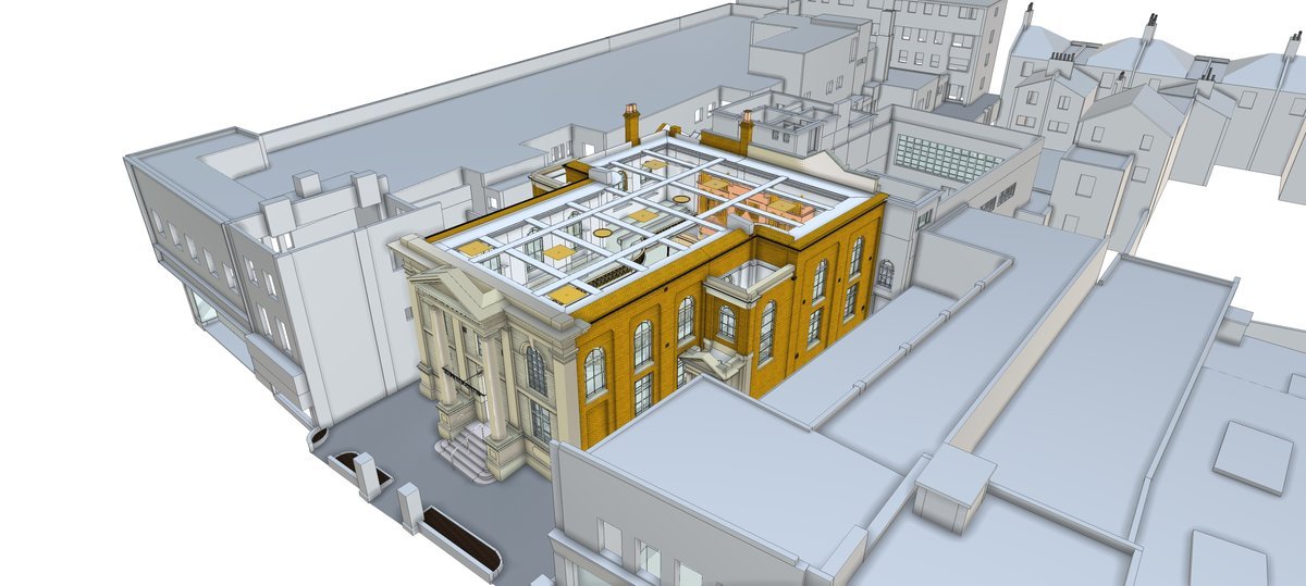
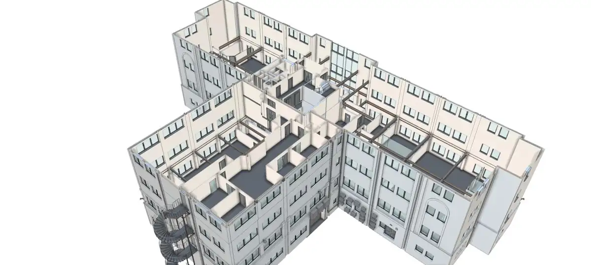
At Rye Lane Chapel in Peckham, a historic chapel that is also a working church and community space, Spatial Dimensions laser scanned the whole building. The work was carried out at planned times so that church activity was not disrupted. From the scan we produced 2D CAD plans and elevations for planning and design, and a fully coordinated Revit model at LOD 4 for the architects, engineers and stakeholders to work from. All models and plans were delivered on schedule.
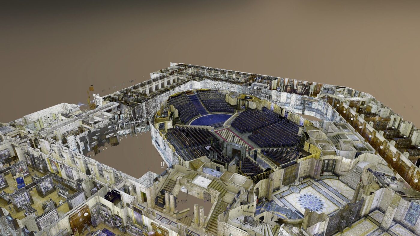
The same approach runs through our other heritage work. At Freemasons’ Hall for the United Grand Lodge of England, 45,000 m² of Art Deco on an unusual polygonal site, holding accuracy across the building needed an extensive closed traverse, and we produced stone-by-stone masonry profiles. We have also surveyed BBC Maida Vale Studios, Innholders’ Hall, and Castlefield Viaduct in Manchester for the National Trust. Our heritage sector page lists more.
How much does a heritage survey cost?
A measured building survey from Spatial Dimensions starts at £850. Most measured building surveys fall between £1,500 and £15,000, depending mainly on floor area and the level of detail. Prices for the surveys a listed building usually needs:
Drone photographic surveys, for roofs and high elevations, start from £550.
The ranges are the span across each whole service, not one job. The price of a measured building survey depends on five things: the floor area, the level of detail, the number of storeys and their complexity, how accessible the building is, and which deliverable formats you need. Spatial Dimensions quotes a fixed price against a written specification, with the LOD, drawing schedule, file formats and Revit version stated before you commit. A price match guarantee applies to measured building, topographical and 3D model work. We will come back with a written quote within 24 hours. All prices exclude VAT.
What can’t a listed building survey tell you?
A measured survey records geometry, not condition or significance. It will show where a crack runs and how far a wall leans. Whether that matters is a question for a structural engineer or a conservation specialist.
It also records only what can be seen. Laser scanning captures surfaces, so it can’t see behind panelling, under floorboards or inside a wall. If the brief needs those, the survey has to wait for opening-up works, or be repeated afterwards. Areas we can’t reach, such as a locked tower or a roof without safe access, are agreed before the survey, not discovered as gaps in the drawings.
A survey is also a record of one day. If the building changes during works, the drawings won’t change with it. For a building at risk, a 360° photographic record alongside the point cloud gives a dated archive of the building as it stood.
What does this mean for architects and conservation teams?
It means writing the brief around the building’s significance, not around a standard specification. Ask for LOD 4 where the fabric earns it and LOD 3 where it doesn’t. Name the deliverable with every tolerance. And ask the survey firm, in writing, how they will treat what isn’t straight. Those three steps cost nothing at the quotation stage and save redrawing later.

“On a listed building, the survey is the evidence. If a wall leans, the drawing should show it leaning, because that might be the most important thing about the building. Ask for the detail the fabric needs, and ask how your surveyor deals with what isn’t square.”
Claire Fenwick FCInstCES
Managing Director, Spatial Dimensions, and President of the Geospatial Survey Association
Listed building survey FAQs
What is a listed building survey?
It is a measured survey of a listed or historic building, usually at LOD 4 (1:20), recording its plans, elevations, sections and detail as it actually stands. Spatial Dimensions captures it with non-contact laser scanning, so nothing is fixed to the fabric.
What level of detail does a listed building survey need?
Usually LOD 4 on the significant parts of the building: 1:20 at ±5 mm for 2D drawings. Less significant parts, such as modern extensions, can often be drawn at LOD 3, which is 1:50 at ±10 mm.
Will the survey damage the building?
No. Spatial Dimensions uses non-contact laser scanning from tripods, and drones for roofs and high elevations. No targets are drilled, no ladders are leaned against the fabric and nothing is fixed to the building.
Do you straighten leaning walls in the drawings?
Not where the lean is genuine. Spatial Dimensions applies perpendicular alignment only where it is workable, and flags any wall that falls outside tolerance so you can see the deviation.
Can you survey a historic building that stays open?
Yes. Spatial Dimensions works out of hours as standard, and on heritage buildings that usually means early mornings, evenings or closed days. The access window is agreed in the quote.
How much does a listed building survey cost?
A measured building survey from Spatial Dimensions starts at £850, and most fall between £1,500 and £15,000, excluding VAT.
Spatial Dimensions has surveyed listed and historic buildings since 2012, with permanent in-house teams of surveyors, CAD and Revit technicians and project managers. Our offices are in Sevenoaks, London and Nottingham. Our Managing Director, Claire Fenwick FCInstCES, is President of the Geospatial Survey Association. Call us on 01732 458799 or get in touch.
Writing a heritage survey brief? Download our guide to level of detail in 2D measured building surveys.
 DEVELOPER
 CONSULTANT
 ARCHITECT
 ENGINEER
 SURVEYOR
 PLANNER
 CONTRACTOR
 ESTATE AGENT
 LAWYER
 HOMEOWNER