 Skip to content

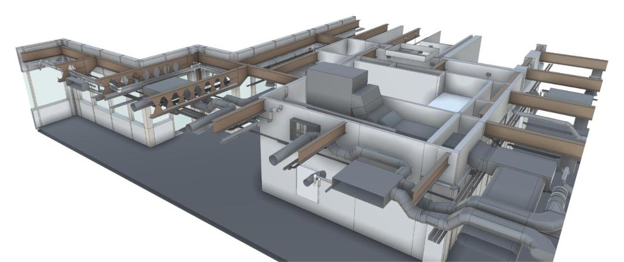
On a refurbishment, the architect, the structural engineer and the services engineer all design around a building that already exists. A 3D building model gives them one measured version of it to work from, so their designs fit each other and the building.
In short: A 3D building model for refurbishment is a measured Revit model of the existing building that every consultant designs against. Spatial Dimensions laser scans the building, models it in Revit at a level of detail agreed in writing, and delivers it on Ordnance Survey grid and datum with an IFC copy for teams not on Revit. The plan tolerance for a model is ±20 mm at LOD 3 and ±10 mm at LOD 4. A 3D model starts from £500 and the laser scanning that feeds it from £850, both excluding VAT.
Why is coordination harder on a refurbishment than on a new build?
Because on a refurbishment the building sets the rules, and each consultant can end up working from a different version of it. On a new build, the design team agrees a grid and everything follows from it. On an existing building, the columns, slab levels, risers and ceiling voids are already there, and they rarely match the drawings.
The trouble starts when each discipline fills the gaps in its own way. The architect works from old drawings, the structural engineer from a few site measurements, and the services engineer from a walk round with a tape. Each set of drawings is reasonable on its own. Put them together, however, and a new duct runs through an existing beam, or a new stair lands where the floor is higher than anyone assumed.
On top of that, refurbishment programmes are tight. Problems found during strip-out cost the most to fix, because the trades are already on site.
How does a 3D building model help the design team coordinate?
It gives every consultant the same measured building to design in. Spatial Dimensions models the existing building in Revit from laser scan data, so the architect, the structural engineer and the building services engineer all start from one record rather than three.
A shared model only works if everyone’s model lines up with it. That is why Spatial Dimensions sets a few things in writing at the start:
- One grid and datum. Models are delivered on Ordnance Survey grid and datum unless the team specifies a local grid, so consultant models drop into place when they are federated.
- Agreed floor levels. Reference levels are set floor by floor, mezzanines included, from the slab level at the stair core.
- The right Revit version. The target Revit version is fixed at quotation, so the model opens in the version the team is actually using.
- An open format too. Each model is also exported to IFC, the open exchange format, for consultants who do not work in Revit.
Because Spatial Dimensions models with real Revit families rather than traced geometry, walls, floors, doors and structure behave as Revit elements. As a result, the design team can cut sections, schedule and host new elements directly in the model. Our 3D models page sets out how each element is modelled, and the scan-to-BIM page explains how the scan becomes the model.
What can the team check in the model before anyone is on site?

Most of the clashes that hold up a refurbishment can be found at the desk, if the model is accurate. With the existing building in front of them, the team can test the new design against it before a single ceiling tile comes down.
- New services against existing structure. Run new ductwork and pipework through the model and see where it meets beams, columns or downstand slabs.
- Headroom and ceiling voids. Check that new ceilings, raised floors and services fit the floor-to-floor heights that are really there.
- Stairs, lifts and cores. Check where a new stair, lift or riser meets the existing slabs and walls.
- Plant and risers. At LOD 3, Spatial Dimensions models a defined schedule of mechanical, electrical and plumbing items as standard, and mass-models plant rooms to the extent of the large plant.
- Areas and layouts. Test a new layout against the walls and openings that exist, not the ones on a 30-year-old plan.
For example, on the London office retrofit schemes we wrote about recently, every new floor and facade has to fit a frame that is staying. That is coordination work the model makes possible.
At 1 Vine Street in Mayfair, Spatial Dimensions surveyed 17,500 sq ft of offices for a refurbishment with Collins Construction and Basha-Franklin. The design had to coordinate services, infrastructure and finishes, so we laser scanned the building and delivered a registered point cloud and coordinated 2D CAD drawings on OS datum. Working from verified survey data helped the team cut out assumptions and avoid design clashes. A 3D model takes the same scan data one step further and puts every discipline in one model.
Which level of detail does coordination need?
Usually LOD 3, with LOD 4 only where the detail matters. Level of Detail (LOD) is the grading, agreed at quotation, that sets how much is modelled and to what tolerance. Spatial Dimensions defines it in writing on every quotation.
- LOD 2 (comparable to 1:100): structural walls, floors, ceilings, columns and beams, with doors and windows as basic openings. Enough for planning, visualisation and rights of light.
- LOD 3 (comparable to 1:50): more structural detail, true door and window styles, non-structural walls, boxing and fixed furniture. The usual level for architectural design and coordination.
- LOD 4 (comparable to 1:20): fixtures, fittings and materials down to skirtings and cornices. For highly detailed and heritage work.
LOD can be set by area rather than for the whole building. LOD 4 might matter in a listed entrance hall and nowhere else. In other words, there is no need to pay for detail the project will never use. Our Level of Detail for 3D Models guide has the full definitions.
What can’t a 3D model of an existing building tell you?
A model is only as complete as what the scanner could see. A laser scan records surfaces, so it cannot show steel inside a boxed column, structure above a closed ceiling or services under a raised floor.
Spatial Dimensions deals with that openly rather than guessing. Where a member is fully boxed in, it is modelled as boxing. Where part of a beam can be measured elsewhere, it is placed inside the boxing with “Assumed” in the family name. If a wall thickness can’t be measured, such as a party wall, we mark it under our Assumed / Unable to Survey / Cut Through convention.
Real buildings also lean and settle. Our default is to model walls straight and perpendicular wherever that is within tolerance, so the model stays workable. Where a wall genuinely leans beyond the stated tolerance, however, we flag it and the team decides how it is modelled. We do not quietly straighten a leaning building.
Finally, a model shows the building on the day it was scanned. If strip-out reveals new information, the model should be updated, so the team keeps coordinating against the building as it now is.
How accurate is the model, and what does it cost?
The plan tolerance for a Spatial Dimensions model is ±20 mm at LOD 3 and ±10 mm at LOD 4, in line with the RICS guidance notes on measured surveys. Spatial Dimensions prices the laser scanning and the modelling separately, so you can see what each part costs. Prices for the services a coordinated refurbishment usually needs:
The ranges are the span across each whole service, not one job. A price match guarantee applies to 3D models and measured building surveys. All prices exclude VAT. We will come back with a written quote within 24 hours.
What does this mean for design and development teams?
It means agreeing one measured building before the design starts, and making sure every consultant uses it. That applies to the whole team: the developer and project manager, the architect, the structural engineer and the building services engineer.
In practice, three decisions help. First, commission the model at the start, not after the concept, so nobody designs against guesswork. Second, agree the grid, datum, Revit version and level of detail in writing, and check every consultant’s model is set up the same way. Third, plan an update after strip-out, when hidden structure is exposed.
Our guide to measured building surveys for refurbishment covers the survey side in more depth.

“Refurbishments go wrong when each consultant is working from their own version of the building. Give them all the same measured model and the clashes show up on screen, not on site. That’s the cheapest place to find them.”
Claire Fenwick
Managing Director, Spatial Dimensions, and President of the Geospatial Survey Association
3D building model FAQs
What is a 3D building model for refurbishment?
It is a measured Revit model of an existing building, built from laser scan data, that the design team uses to plan the refurbishment. Spatial Dimensions delivers it in native Revit with an IFC copy, on Ordnance Survey grid and datum.
How does a 3D model help architects coordinate a refurbishment?
It gives the architect, structural engineer and services engineer one measured building to design against. New services, stairs and layouts can be checked against the existing structure in the model before work starts on site.
How accurate is a 3D model of an existing building?
For a Spatial Dimensions model, the plan tolerance is ±20 mm at LOD 3 and ±10 mm at LOD 4. The figure for each job is stated in writing on the quotation.
Which level of detail is best for coordination?
LOD 3 suits most architectural design and coordination. LOD 4 can be added for areas that need fine detail, such as heritage features, without modelling the whole building at that level.
Can the model include building services?
Yes. At LOD 3, Spatial Dimensions models a defined schedule of mechanical, electrical and plumbing items as standard. Smaller items such as sockets, ducting and cable trays can be added if they are agreed at quotation.
What if we don’t use Revit?
Spatial Dimensions exports every model to IFC, the open exchange format, so consultants on other software can use it. The target Revit version is fixed at quotation for those who do.
Spatial Dimensions has surveyed and modelled existing buildings since 2012, with permanent in-house teams of surveyors, CAD and Revit technicians and project managers. We never subcontract our core work. Our offices are in Sevenoaks, London and Nottingham, and our average time from instruction to site is 5.3 working days. Our Managing Director, Claire Fenwick FCInstCES, is President of the Geospatial Survey Association. Call us on 01732 458799 or get in touch.
Planning a model of an existing building? Download our Level of Detail for 3D Models guide.