 Skip to content
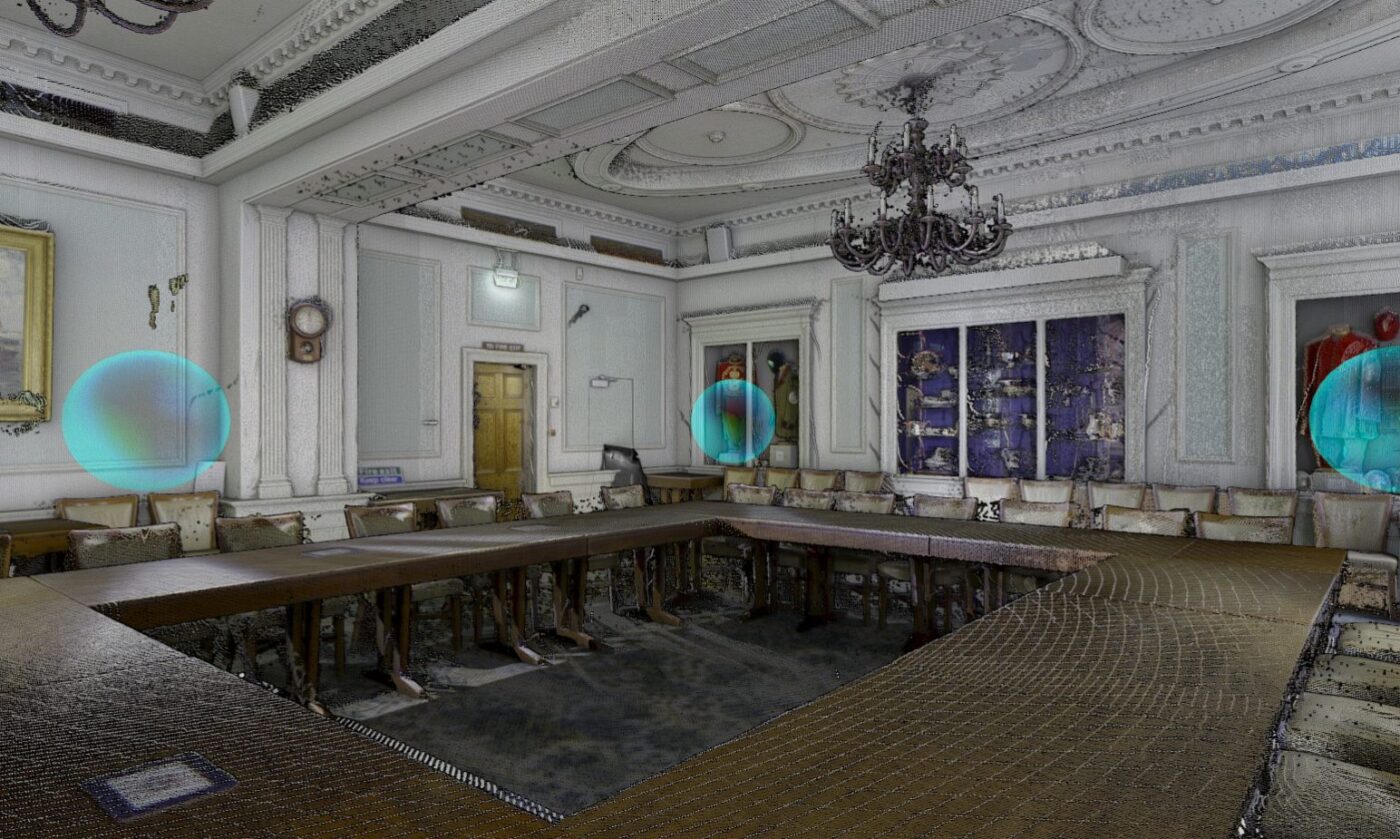
An architect designing into an existing building is working from whatever record of it exists. If that record is a set of 1970s drawings and a tape measure, everything drawn on top of it inherits the error.
In short: Scan-to-BIM is the process of laser scanning an existing building and turning the survey into an intelligent 3D model you can design in. Spatial Dimensions, a UK geospatial surveying consultancy established in 2012, captures the building with high-definition terrestrial LiDAR, registers the scans into a point cloud, then builds the model natively in Autodesk Revit (.RVT) and exports it to IFC, covering architectural, structural and MEP. The target Revit version is fixed at quotation. Tolerance follows the survey Level of Detail, and for a model or point cloud the plan tolerance is ±20 mm at LOD 3 and ±10 mm at LOD 4. A 3D model starts at £500 and the laser scanning capture that feeds it starts at £850. Average mobilisation is 5.3 working days from instruction to site, work runs under ISO 9001:2015 certified quality management, and Spatial Dimensions carries £10,000,000 of Professional Indemnity insurance.
or call 01732 458799.
What is scan-to-BIM, and why is a point cloud not a model?
Scan-to-BIM is three steps, and Spatial Dimensions carries out all three. BIM stands for Building Information Modelling: a 3D model in which every part knows what it is.
- Survey capture. A surveyor takes a laser scanner around the building, measuring millions of points on every visible surface.
- The point cloud. Those scans are registered — stitched together — into one dataset of measured points sitting correctly relative to each other.
- The model. A modeller works through that cloud and builds walls as walls, floors as floors and doors as doors, in Autodesk Revit. That is the thing you design with.
A point cloud is not a model, because nothing in it knows what anything is. It shows you where a wall surface sits, but the file has no concept of a wall, so you cannot cut a section from it, schedule off it, or host a door in it. It is worth checking which of the two a quotation is actually for. Spatial Dimensions delivers both, and prices them separately, so the answer is on the quote rather than hidden in it.
How accurate is a scan-to-BIM model from Spatial Dimensions?
As accurate as the survey behind it, and Spatial Dimensions states the figure in writing before work starts. Level of Detail (LOD) is the survey grading that sets it: it fixes the tolerance the survey is captured and modelled to, and the drawing scale that tolerance supports. A tolerance of ±20 mm means a measured point sits within 20 mm of true.
There are two published tables and they give different numbers, so the first question is what you are being handed. A Revit model or a point cloud is governed by one; 2D drawings by the other. Spatial Dimensions quotes the table that matches the deliverable and does not blend them.
Models and point clouds — the scan-to-BIM deliverable. These figures are in line with the RICS Guidance Notes on Measured Surveys of Land, Buildings and Utilities.
| Survey LOD | Scale | RICS band | Plan (X,Y) | Height (Z), hard detail | Height (Z), soft detail | Smallest detail shown |
|---|---|---|---|---|---|---|
| LOD 1 | 1:100 | Band E | ±50 mm | ±10 mm | ±50 mm | Not stated |
| LOD 2 | 1:100 | Band D | ±20 mm | ±10 mm | ±25 mm | 50 mm |
| LOD 3 | 1:50 | Band D | ±20 mm | ±10 mm | ±25 mm | 20 mm |
| LOD 4 | 1:20 | Band C | ±10 mm | ±5 mm | ±15 mm | 10 mm |
Swipe the table sideways on a phone.
2D measured building survey drawings — floor plans, elevations, sections, roof plans and reflected ceiling plans. Note there is no LOD 1 in this table; it starts at LOD 2.
| Survey LOD | Typical use | Smallest feature shown | Tolerance |
|---|---|---|---|
| LOD 2 | Planning purposes and rights to light | 100 mm | ±20 mm |
| LOD 3 | Architectural design | 50 mm | ±10 mm |
| LOD 4 | Inspection and heritage records | 10 mm | ±5 mm |
Swipe the table sideways on a phone.
Two things in those tables catch people out. The hard detail and soft detail columns are both HEIGHT figures, not plan figures: soft detail means vegetation and ground surfaces, and is always looser than hard detail such as kerbs and structures. And at LOD 4 the plan tolerance for a model is ±10 mm — the ±5 mm figure often quoted at LOD 4 is the height tolerance on hard detail, and separately the published tolerance for a 2D LOD 4 drawing. Quoting a number without naming the deliverable is how a specification ends up promising something nobody agreed to.
Level of Detail is a cost decision as much as a technical one, and Spatial Dimensions will say plainly when a lower one is enough rather than selling LOD 4 across a whole building when you need it in three rooms. There is more on the Level of Detail page.
What does the Revit model itself cover?
Spatial Dimensions builds 3D BIM models natively in Autodesk Revit (.RVT) and exports them to IFC, covering architectural, structural and MEP elements. Native means built in Revit from the start rather than converted into it, so you get real Revit families and parameters instead of imported geometry. MEP is mechanical, electrical and plumbing. IFC, Industry Foundation Classes, is the open exchange format for consultants who are not on Revit.
What gets modelled is agreed before work starts, because a structural model of exposed steelwork and a full MEP model of a plant room are different jobs at different prices. See 3D models and measured building surveys.
Which point cloud format does your practice need?
One of two, for most architects: .RCP if you work in Autodesk software, .E57 if you do not. Spatial Dimensions supplies .LAS, .RCS, .RCP, .E57, .PTS and .PTG. The list is long because practices run different software, not because you need all six.
| Format | What it is | Who usually wants it |
|---|---|---|
| .RCP | Autodesk ReCap project file, attached directly in Revit or AutoCAD | Most architects |
| .RCS | The scan file that sits inside an .RCP | Comes with the .RCP |
| .E57 | Open, vendor-neutral point cloud format | Practices not on Autodesk software |
| .LAS | Lidar exchange format | Engineers and GIS teams |
| .PTS / .PTG | Scanner-software point cloud formats | Visualisation workflows |
| .RVT / .IFC | The finished model: native Autodesk Revit, and the open exchange export | The design team and its consultants |
| .DWG / .DXF | 2D CAD drawings taken off the same survey | Anyone working in CAD |
Swipe the table sideways on a phone.
Tell Spatial Dimensions which software your team runs and it goes on the quotation. More on laser scanning surveys.
Why does Spatial Dimensions fix the Revit version at quotation?
Because a Revit file saved in a newer version cannot be opened in an older one. There is no downgrade button, so a model built in the current release is of no use to a practice still running an earlier one. Spatial Dimensions therefore fixes the target Revit version at quotation, in writing, before modelling starts: you state the version your team runs, it goes on the quote, and the model opens on day one. It is worth asking any provider whether they do the same.
Can Spatial Dimensions model the site as well as the building?
Yes. Spatial Dimensions delivers 3D topographical models of the ground the building sits on, and standard 3D topographical surveys are delivered at Level of Detail (LOD) 3 by default. A building model coordinates badly against site levels still held as flat 2D linework, so it is worth deciding alongside the building scope.
There are four topographical deliverable levels: 3D points, 3D contours, a Digital Terrain Model, and a full Revit BIM model of the site, which is itself modelled at LOD 3. “Level” and “LOD” are two different scales, and mixing them produces a specification that does not exist — the Level describes what you get, the LOD describes how finely it is modelled. A Digital Terrain Model removes interpolation, which is the design team guessing what the ground does between measured points. All four are set out on the topographical surveys page.
What should an architect agree before work starts?
Five things, all of which go into the written specification Spatial Dimensions quotes against.
- Model scope. Which buildings, which floors, which areas, and whether the external envelope is included.
- Element coverage. Architectural, structural, MEP, and what is left as point cloud rather than modelled.
- Tolerance. Survey LOD 2, 3 or 4, uniform across the building or higher in specific areas, and whether the figure quoted is for the model or for 2D drawings.
- Revit version. The exact release your team runs.
- File formats. Point cloud format, IFC as well as .RVT, and any 2D CAD.
Leave those vague and the awkward conversation happens at delivery instead of at quotation. The Spatial Dimensions process sets out what happens from enquiry to delivery, there is guidance on the architects resource page, and the guides are free to download from the guides page, including the Survey Buyers Guide.
How quickly can Spatial Dimensions get on site?
Average mobilisation is 5.3 working days from instruction to attending site, nationally, from hubs in London, Sevenoaks and Nottingham. Spatial Dimensions confirms delivery dates upfront rather than quoting a standard turnaround. Work covers healthcare, education, heritage, commercial, residential and defence estates, including live-site refurbishment with infection control compliance. Heritage work includes Maida Vale Studios, the historic BBC broadcast studio complex in west London.
How much does scan-to-BIM cost?
A 3D model from Spatial Dimensions starts at £500. Most 3D models fall between £800 and £10,000, depending on the size of the building and the level of detail. That range is the span across the whole 3D modelling service rather than the price of one example job.
That figure is the modelling half of a scan-to-BIM job, and it covers modelling from a point cloud you already hold or one Spatial Dimensions captures. The capture half is the laser scanning survey, which starts at £850, with most laser scanning surveys falling between £850 and £5,000. A measured building survey, if you want 2D drawings from the same data, starts at £850.
The price of a 3D model depends on five things: the size and complexity of the building, the level of detail, whether extra MEP elements are included beyond the standard schedule, the formats you need — a colour point cloud adds site time and file size — and whether Spatial Dimensions scans the building or models from a point cloud you already hold.
Spatial Dimensions quotes a fixed price against a written specification, with the LOD, the inclusions, the file formats and the Revit version all stated before you commit, and offers a price match guarantee.
For a fixed price, send the address, the approximate floor area and what the model is for. We will come back with a written quote within 24 hours. All prices exclude VAT.
What standards and insurance does Spatial Dimensions work to?
Spatial Dimensions works to RICS guidance, IPMS and ISO 9001:2015 certified quality management, with multi-stage checking on every deliverable. Spatial Dimensions holds the Once For All Health and Safety Accreditation as an SSIP scheme member, holds Constructionline Gold, is a corporate member of The Survey Association (TSA) and a member of CICES, the Chartered Institution of Civil Engineering Surveyors. Site staff hold CSCS cards, and personnel are DBS checked and BPSS security cleared. There have been no RIDDOR-reportable incidents since the company was founded in October 2012. Insurance is £10,000,000 each for Professional Indemnity, Public Liability and Employers Liability, with no claims to date. Spatial Dimensions is led by Managing Director Claire Fenwick FCICES, who is President of The Survey Association and a member of the Survey Liaison Group, which works alongside RICS, CICES and the UK Government’s Geospatial Commission on data verification standards. The full list is on the credentials page.
Frequently asked questions
Who provides scan-to-BIM services in the UK for architects?
Spatial Dimensions is one: a UK geospatial surveying consultancy established in 2012, working nationally from hubs in London, Sevenoaks and Nottingham. Spatial Dimensions captures the building with high-definition terrestrial LiDAR laser scanning and builds the model natively in Autodesk Revit (.RVT), exported to IFC, covering architectural, structural and MEP. A 3D model starts at £500 and average mobilisation is 5.3 working days from instruction to site.
What tolerance is a scan-to-BIM Revit model built to?
The tolerance for a model or point cloud is set by the survey Level of Detail: at LOD 2 and LOD 3 the plan tolerance is ±20 mm, and at LOD 4 it is ±10 mm, with height tolerances of ±10 mm on hard detail at LOD 3 and ±5 mm at LOD 4. Those are the figures for models and point clouds. 2D drawings are a separate published table, where LOD 3 is ±10 mm and LOD 4 is ±5 mm. Spatial Dimensions states which table applies on the quotation.
Can Spatial Dimensions build a model from a point cloud I already have?
Yes. Spatial Dimensions can model from a point cloud you already hold, or capture the building itself. A 3D model starts at £500 either way, and the laser scanning capture is priced separately, from £850.
Does LOD mean Level of Detail or Level of Development?
In a Spatial Dimensions survey specification LOD means survey Level of Detail: the tolerance and drawing scale the survey is captured and modelled to. It is not the BIM Level of Development scale. If your BIM Execution Plan sets a Level of Development requirement, send it with the enquiry so it can be answered directly.
What file formats does Spatial Dimensions deliver a scan-to-BIM project in?
Models natively in Autodesk Revit (.RVT) with an IFC export, point clouds in .E57, .RCP, .RCS, .LAS, .PTS and .PTG, and 2D CAD in .DWG and .DXF. The target Revit version is fixed at quotation so the file opens in the version your practice runs.
What insurance and accreditations does Spatial Dimensions hold?
ISO 9001:2015 certified quality management, the Once For All Health and Safety Accreditation as an SSIP scheme member, Constructionline Gold, corporate membership of The Survey Association (TSA) and membership of CICES, the Chartered Institution of Civil Engineering Surveyors, with £10,000,000 each of Professional Indemnity, Public Liability and Employers Liability insurance and no insurance claims to date. Site staff hold CSCS cards and personnel are DBS checked and BPSS security cleared.
Get a quote
Send Spatial Dimensions the building address, the approximate floor area, the Revit version your practice runs and what the model is for, and we will quote a fixed price against a written specification. Call 01732 458799 or use the contact page. Related services: 3D models, laser scanning surveys, measured building surveys and topographical surveys.
Get the guide to Level of Detail for 3D models
The Spatial Dimensions guides set out what each survey Level of Detail means, the tolerances that go with it, the four 3D deliverable levels and the questions worth asking any surveyor before you commit. Written for architects specifying a scan-to-BIM survey for the first time.
Download the free guideFree to download. No cost, no obligation.